ISRO Successfully Launches NISAR, World’s Most Expensive Earth Imaging Satellite
Date: July 30, 2025
Category: Space | Technology | India
Tags: ISRO, NASA, NISAR, Earth Imaging, Satellite, Space Research
A Historic Collaboration in Earth Observation
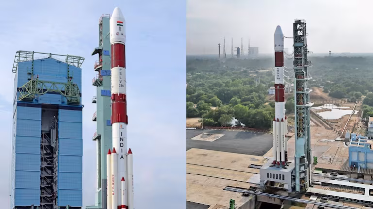
The Indian Space Research Organisation (ISRO), in collaboration with NASA, has successfully launched NISAR — short for NASA-ISRO Synthetic Aperture Radar — marking a milestone in global earth monitoring and Indo-US space cooperation.
Launched from the Satish Dhawan Space Centre, the NISAR satellite is the most expensive Earth imaging satellite ever developed, with a joint budget estimated to exceed $1.5 billion USD.
What is NISAR?
NISAR is a dual-frequency radar imaging satellite designed to monitor and analyze the Earth’s surface changes with unprecedented accuracy. Equipped with L-band and S-band synthetic aperture radar systems, the satellite can detect minute changes in land movements, ice sheet shifts, forest biomass, and even groundwater depletion.
This will significantly help in disaster management, climate change tracking, agriculture planning, and infrastructure monitoring.
The Mission’s Key Highlights
- Name: NISAR (NASA–ISRO Synthetic Aperture Radar)
- Launched by: ISRO with collaboration from NASA
- Launch Vehicle: GSLV Mk II
- Launch Site: Sriharikota, Andhra Pradesh
- Orbit: Sun-synchronous low Earth orbit (~747 km altitude)
- Mission Duration: Minimum 3 years, extendable to 5+ years
- Mass: Approx. 2,800 kg
A Model of Global Cooperation
While NASA provided the L-band radar, communication subsystems, and GPS receivers, ISRO contributed the S-band radar, spacecraft bus, launch vehicle, and satellite integration. NISAR exemplifies international collaboration for peaceful and scientific purposes.
“This is a historic day for India and a proud moment for the global scientific community,” said ISRO Chairman Dr. S. Somanath.
Why NISAR Matters
NISAR will deliver crucial data on:
- Earthquakes and volcanoes
- Ice sheet collapse and glacier melt
- Deforestation and soil degradation
- Urban infrastructure stress
- Flood and landslide prediction
This will empower scientists and policymakers globally with real-time, accurate data.
Data Accessibility
All data generated by NISAR will be made freely available to the public and research institutions globally, aligning with both ISRO’s and NASA’s open data policies.
What’s Next?
With NISAR in orbit, ISRO continues its upward trajectory toward space-based innovation and global collaboration. This success lays the foundation for future missions involving deep space exploration, human spaceflight, and advanced Earth science.
Author’s Note:
India’s space ambitions are no longer just about reaching space — they are now about using space for the betterment of life on Earth. NISAR proves that when nations unite for science, everyone wins.